Brandon, Iowa
Appearance
Brandon, Iowa | |
|---|---|
 | |
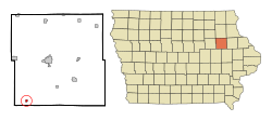
 Location of Brandon, Iowa | |
| Coordinates: 42°18′51″N 92°0′15″W / 42.31417°N 92.00417°W | |
| Country | |
| State | |
| County | Buchanan |
| Area | |
| • Total | 0.32 sq mi (0.84 km2) |
| • Land | 0.32 sq mi (0.84 km2) |
| • Water | 0.00 sq mi (0.00 km2) |
| Elevation | 827 ft (252 m) |
| Population | |
| • Total | 341 |
| • Density | 1,052.47/sq mi (405.83/km2) |
| Time zone | UTC-6 (Central (CST)) |
| • Summer (DST) | UTC-5 (CDT) |
| ZIP code | 52210 |
| Area code | 319 |
| FIPS code | 19-08155 |
| GNIS feature ID | 0454806 |
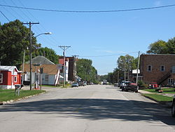
Brandon is a city in Buchanan County, Iowa, United States. The population was 341 at the 2020 census.[2]
Roadside attraction
[change | change source]Brandon is home to Iowa's Largest Frying Pan. Built in 2001, the frying pan weighs over 1,000 pounds.[3]
References
[change | change source]- ↑ "2020 U.S. Gazetteer Files". United States Census Bureau. Retrieved March 16, 2022.
- ↑ 2.0 2.1 "Brandon city, Iowa". United States Census Bureau. Retrieved November 3, 2023.
- ↑ Green, Beth (2008). "World's Largest Frying Pan". Minerva WebWorks LLC. Retrieved 2008-07-05.
